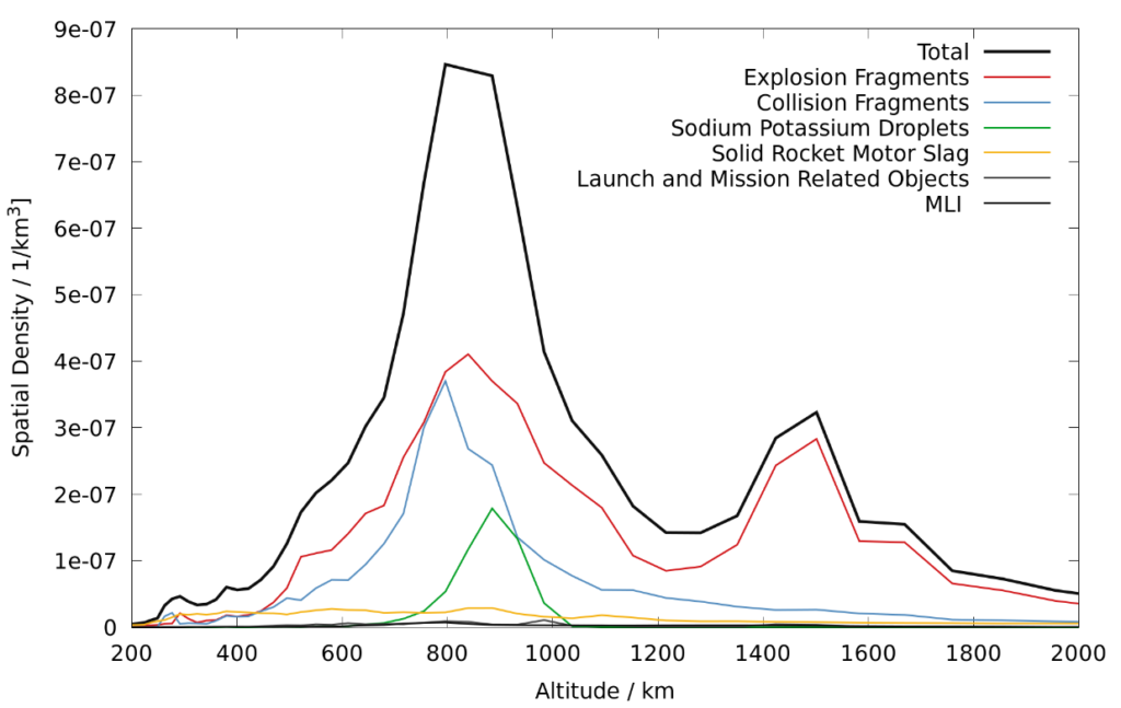
Space is crowded. As of date, more than 300,000 objects larger than 1 cm are in orbit around Earth[1]. The origins of these objects are many fold: Most large objects are satellites(active and used ones), rocket upper stages, and mission related objects such as adapter rings etc. Although they by far include most of the mass, their total count is comparably low: About 4500 satellites are in orbit (less than 2000 of them still active), ca. 2000 are upper stages. Greatest contribution in terms of number of objects are fragments, created during explosions and collisions. Most notable events from the latter kind are a Chinese anti-satellite test from 2007[2] and the collision between the active Iridium 33 and the old Cosmos 2251 satellites[3]. These three major contributors are accompanied by several other sources, such as sodium potassium droplets, released from nuclear reactors used on satellites between 1980 and 1988 and wastes created using solid rocket motors in rocket stages and satellites. This distribution of objects from these different sources along their orbital altitude is shown in Figure 1. Looking at this figure, it becomes apparent that, naturally, altitudes which are of most interest for satellite operators are also those that are populated the most.

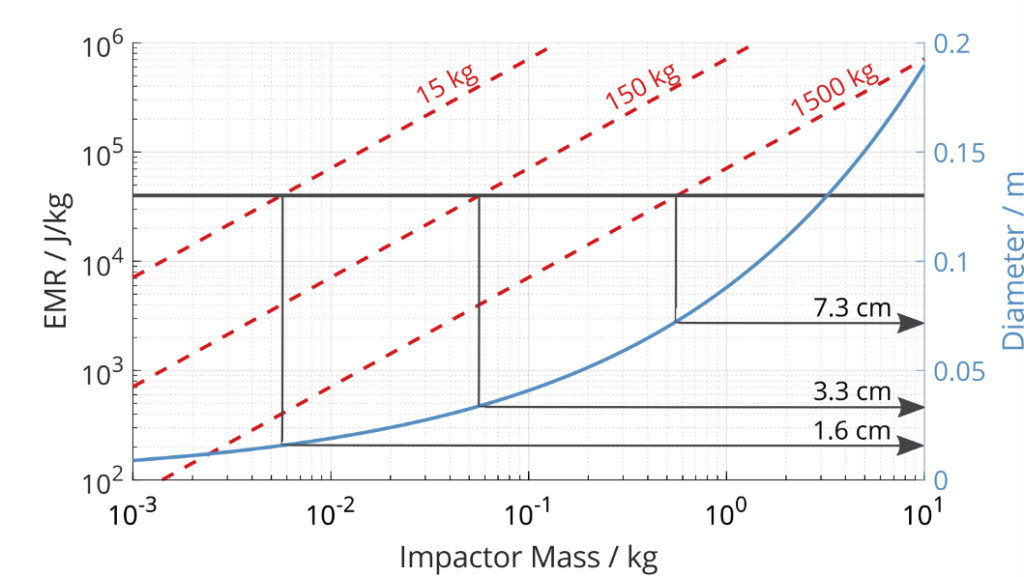
Every one of these objects of them can cause a critical mission failure or even the loss of the complete satellite. As a rough guideline, it is said that from an Energy-to-Mass ratio of 40 J/g[4] an impact leads to a complete destruction of a satellite. Due to the high relative velocities on orbit (which in LEO can reach up to 15 km/s), already rather small objects can lead to these catastrophic collisions. Collisions between satellites and space debris objects happen frequently, although the large share of them has no critical impact on the satellite’s mission. An, incomplete,overview of some past collision events is given in Table 1. Creating an exhaustive list is nearly impossible, as many on-orbit anomalies cannot be fully re-solved. Even though the latest stated collision had a very low EMR, it led to damaging the solar array of Sentinel-1A in an area with a diameter of 40 cm.
| Year | Object 1 | Object 2 | EMR / J/kg | Cat. Frags |
| 1991 | Cosmos 1934 | Debris 13475 | 7.66e4 | 2 |
| 1996 | Cerise | Debris 18208 | 8.3e6 | 1 |
| 2002 | Jason-1 | Unknown | Unkown | 2 |
| 2005 | DMSP 5B F5 Thor | Debris 26207 | 6.28e5 | 699 |
| 2009 | Cosmos 2251 | Iridium 33 | 1.59e7 | 2199 |
| 2013 | Blits | Unknown | Unknown | max. 1 |
| 2016 | Sentinal-1A | Unkwon | ~ 6 | 0 |
Of all objects, currently only about 18,000 are actively tracked by the US Space Command, most of them of size larger than 10 cm in LEO, in higher orbits the minimal visible diameter decreases to about 1 m in the Geostationary Orbit(GEO). If a potential collision is projected, a warning is sent to satellite operators, including information such as the state uncertainties of the objects included in that conjunction, the collision probability, and calculated miss distances. In 2017, about 4,000,000 of these conjunction warnings were sent to satellite operators, leading to more than 100 collision avoidance manoeuvres per year[5].

But this only includes about 70% of all objects larger than 10 cm. To reduce the knowledge gap, the US military is currently building the space fence[6]. With its capabilities, the aim is to track all objects larger than “softball size”, whereas the current catalogue is stated to be complete in LEO for objects larger than “basketball size”. It is assumed that this lower detection threshold will lead to an increase in the number of objects to ~ 160,000. Increasing the number of objects in the catalogue will naturally also increase the number of conjunction warnings, in a first assessment by a factor of 300%[7].
But these numbers are again only valid, if the Low Earth Orbit environment stays similar to how it is today: Currently, Spaceflight is prospering. The number of launched satellites has increased steadily from about 40 in 2005, which was the lowest level since the very beginning of spaceflight, to more than 400 in 2017[8]. A large share of the new launches comes from an increasingly strong commercial spaceflight, delivering products such as telecommunications, Earth observation,and weather data. While these increasing activities help solving a lot of issues on Earth, they also pose new challenges in terms of Low Earth Environment. If only a fraction of published plans becomes realized, altitudes below 500 km will be populated with thousands of new, mostly CubeSat sized small satellite constellations constantly monitoring Earth, more or less classical satellite missions in altitudes between 500 km and 800 km. In higher altitudes, huge communication constellations will be built, consisting of up to several thousand of satellites with masses between 100 kg and 500 kg,constantly cycling up from their launch altitudes in 500 km, and spiralling down for their save disposal in the atmosphere[9],[10].
To keep spaceflight working, current means of safe satellite operations and collision avoidance won’t be feasible anymore. Therefore, OKAPI:Orbits provides software solutions, to easily integrate and automate all aspects of safe operations into mission control systems, starting from pass prediction, orbit determination,orbit and co-variance propagation, up to collision avoidance and manoeuvre optimization.
[1] Flegel, S., Maintenance of the ESA MASTER Model, Final Report to ESA/ESOC contract 21705/08/D/HK, Institute of Aerospace Systems, TU Braunschweig, 2011
[2] Johnson, N. L., Stansbery, E., Liou, J.-C., Horstman, M., Stokely, C., Whitlock, D., The characteristics and consequences of the breakup-up of the FengYun-1C spacecraft, Proceedings of the 58th International Astronautical Congress (IAC), 2007. Paper ID IAC -07- A6.3.01.
[3] Anon., Satellite Collision Leaves Significant Debris Clouds, Orbital Debris Quarterly News, Vol. 13, Issue 2,April 2009
[4] McKnight, D. S., Collision and breakup models:pedigree regime, and validation/verification, Briefing presented to the National Research Council Committee on Space Debris Workshop, Irvine, CA, USA, 1993
[5] Guadalupe V., Mollett R., 18 SPCS: Who We Are, What We Do, and Where We’re Going, CNES CA Workshop 2017
[6] The Space Fence is space surveillance system built for the US Airforce designed to detect and track objects on Earth’s orbits. It is located on Kwajalein Atoll, in the Marshal Islands.
[7] As of date, there is no “official”estimation on the capabilities of the space fence. All info stated here have been taken from https://directory.eoportal.org/web/eoportal/satellite-missions/s/space-fence, and should only be used as rough guidelines.
[8] Even considering that about 25% of these satellites were launched for a single company makes 2017 the year with most launched satellites in decades.
[9] Bastida Virgili, B., Dolado, J., Lewis,H.. Radtke, J., Krag, H., Revelin, B., Cazaux, C., Colombo, C., Crowther,R., Metz, M., Risk to space sustainability from large constellations of satellites Acta Astronautica, 2016, 126, 154 – 162.
[10] Radtke, J., Stoll, E., Lewis, H.G., Beck, J., Bastida Virgili, B., To launch or not to launch -responsibilities of small satellites for a sustainable space environment Proceedings of the 68th International Astronautical Congress, Adelaide,Australia, 2017.

